


Természetjáró, a túratervező
Perihal Természetjáró, a túratervező
Pemandu pelancong dalam talian Hungary, dibangunkan khas untuk pejalan kaki, penunggang basikal, pelari jejak, pendaki batu dan pencinta sukan air, menampilkan perancang pelancongan terbina dalam, serta ratusan lawatan yang disyorkan dan beribu-ribu pemandangan, semuanya dengan penerangan terperinci dan banyak gambar , boleh dilihat dengan selesa pada peta interaktif. Tersedia secara percuma, dengan pilihan langganan untuk fungsi lanjutan.
Ciri
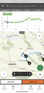
• Pelbagai interaktif, boleh dizum, divektorkan, peta kembara sedunia dengan semua denai yang ditanda, menunjukkan kedudukan semasa anda
• Cara mudah untuk merancang lawatan anda sendiri pada peta dan dapatkan panjang, tempoh dan profil ketinggian dengan segera
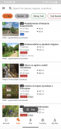
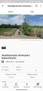
• Lebih daripada seribu lawatan yang disyorkan untuk pejalan kaki, penunggang basikal, pelari denai dan berkano, dengan data praktikal, penerangan terperinci tentang pemandangan terbaik berdekatan, latar belakang semula jadi dan budaya, gambar berkualiti baik dan maklumat tentang cara untuk ke sana
• Beribu-ribu pemandangan yang disyorkan di Hungary, termasuk menara tinjau, titik panorama semula jadi, kereta api hutan, kubu dan muzium, dengan penerangan terperinci, gambar berkualiti baik serta maklumat tentang cara untuk ke sana
• Beratus-ratus penginapan, termasuk pondok, hotel dan pangsapuri pelancongan, berhampiran denai bertanda
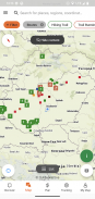
• Koleksi berguna dengan paparan peta: pantai di sekitar tasik Balaton, arena luncur ais, taman botikal, laluan larian denai terbaik, tempat memanjat batu, lawatan untuk orang kurang upaya dsb.
• Notis, amaran dan penutupan
• Muat turun bahagian peta, lawatan dan pemandangan untuk kegunaan luar talian
• navigasi on-the-fly di sepanjang laluan dengan profil ketinggian langsung dan arahan suara
• Rakam laluan anda
• BuddyBeacon: kongsi kedudukan anda dengan rakan secara langsung
• Lawatan Biru Hungary yang lengkap, dengan bahagian dan laluan rasmi, POI dan penginapan
• Segerakkan semua kandungan anda antara komputer dan peranti mudah alih yang menjalankan apl
• Semak ramalan cuaca tempatan
• Penerbangan 3D: pandangan mata maya bagi lawatan itu
• Alat berguna terbina dalam, seperti peak finder(Skyline) dan compass dengan kedudukan semasa anda
• Perkhidmatan komuniti: nilai dan kongsi kandungan dengan rakan anda
Jam tangan pintar dengan WEAR OS daripada Google
Dengan melihat sekilas jam tangan pintar anda, anda mendapat maklumat tentang kedudukan GPS anda pada peta. Anda boleh merakam trek, mendapatkan data penjejakan dan menavigasi sepanjang laluan. Gunakan jubin apl untuk mengakses laluan berdekatan dengan mudah.
Eksklusif untuk ahli Pro
Pergi ke mana-mana sahaja : Outdooractive Pro berfungsi di luar talian tanpa isyarat mudah alih dan data. Senarai tanpa had juga boleh dibuat dan apl itu bebas iklan. Selain itu, anda boleh melihat imejan satelit, peta Luar Aktif yang unik dengan lebih 30 rangkaian jejak aktiviti dan peta topografi rasmi daripada pembekal berikut:
Tinjauan Ordnance Great Britain, Landranger, Explorer
Maklumat Tanah New Zealand
USGS Utah
Jerman BKG
Austria BEV
Switzerland swisstopo
Perancis IGN
Sepanyol CNIG
Itali
PDOK Belanda
Norway Kartverket
Denmark Kortforsyningen
Sweden Lantmäteriet
Kajian Tanah Negara Finland
GSI Jepun
Peta Global
Eksklusif untuk ahli Pro+
Pro+ juga mengandungi peta rasmi daripada Persatuan Alpine serta peta premium daripada KOMPASS.
Jika anda mempunyai soalan atau cadangan, sila lawati
https://www.termeszetjaro.hu/hu/p/gyakran-ismetelt-kerdesek/41050512 /
Versi desktop kami:
https://www.termeszetjaro.hu/
Ikuti kami di Facebook:
https://www.facebook.com/Termeszetjaro.hu/
Hubungi kami:
termeszetjaro@termeszetjaro.hu
Lagi tentang kad TEKA:
http://www.termeszetjarokartya.hu/
Természetjáró, a túratervező - Maklumat APK
Versi APK: 3.18.4Pakej: com.outdooractive.mtszVersi Terkini Természetjáró, a túratervező
Versi lain


Aplikasi dalam kategori sama

Anda juga mungkin suka...


